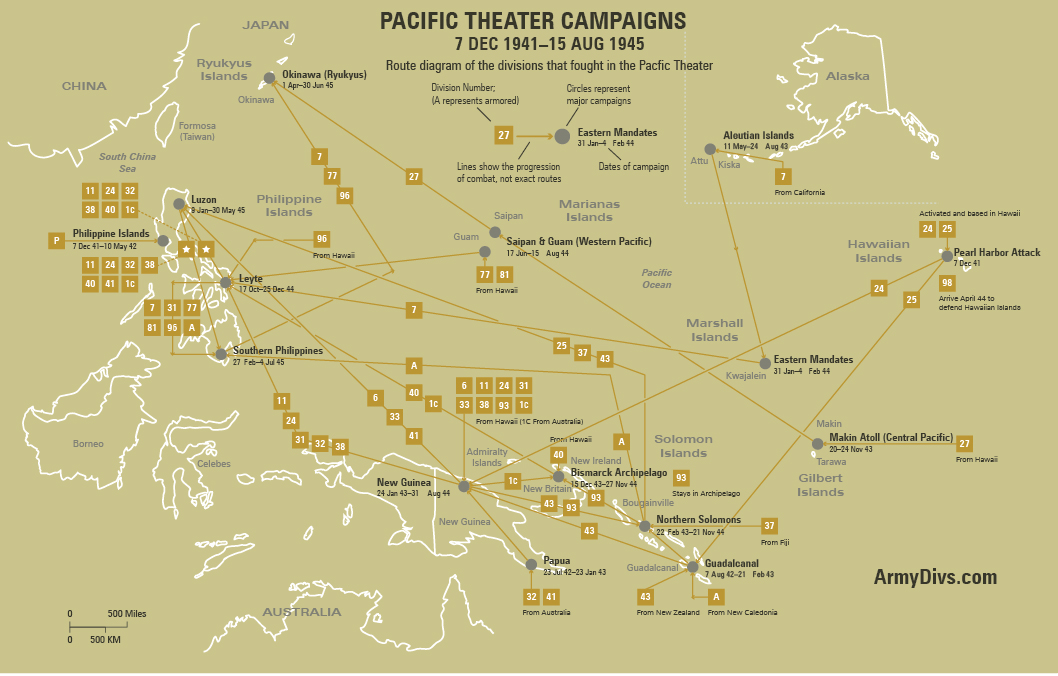
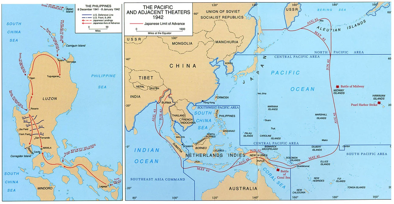
Japan’s offensive against the Philippine Islands began within hours of the attack on Pearl Harbor. General Douglas MacArthur commanded United States Army Forces in the Far East, a mixed American and Filipino force that was still mobilizing when Japanese air attacks struck Clark Field and other bases on 8 December. The destruction of much of the Far East Air Force on the ground sharply reduced the defenders’ ability to contest the invasion. As Japanese landings multiplied, especially at Lingayen Gulf in late December, MacArthur abandoned plans for a forward defense of Luzon and withdrew to Bataan and Corregidor in accordance with earlier war planning.
The Bataan campaign became one of the longest defensive stands of the war’s opening phase. American and Filipino troops, short of food, medicine, ammunition, and air support, held the peninsula for months under increasingly severe conditions. In March 1942 President Franklin D. Roosevelt ordered MacArthur to Australia, leaving Lieutenant General Jonathan M. Wainwright in higher command. Bataan fell on 9 April. Its survivors then endured the Bataan Death March, one of the most notorious atrocities of the Pacific war. Corregidor and the other harbor defenses continued the resistance into May, but on 6 May Wainwright surrendered the island fortress. Organized resistance elsewhere in the Philippines soon collapsed.
The loss of the Philippines was a major strategic and political defeat for the United States, yet the defense imposed real costs on Japan. The prolonged campaign tied down Japanese troops and shipping at a moment when Tokyo was expanding across Southeast Asia and the western Pacific. The defense also became one of the central moral symbols of the early war. MacArthur’s pledge to return gave the campaign an enduring place in the American war narrative and helped shape later Allied strategy in the Southwest Pacific.
Courtesy of the U.S. Military Academy, The West Point Atlas for The Second World War: Asia and the Pacific
The Central Pacific campaign opened with the Japanese attack on Pearl Harbor on 7 December 1941. The assault damaged or sank much of the Pacific Fleet’s battleship force, destroyed aircraft, and killed more than two thousand Americans. Yet the Japanese failed to catch the American carriers in port, and that omission proved decisive. Under Admiral Chester W. Nimitz, who assumed command in the Pacific later that month, the United States rebuilt its naval striking power around the carrier force and the industrial capacity that was beginning to mobilize across the country.
The decisive turning point in the campaign came at Midway in June 1942. American intelligence identified the Japanese plan in advance, allowing Nimitz to position his available carriers for an ambush. In a few hours of carrier battle, U.S. naval aviators sank four Japanese fleet carriers, inflicting losses Japan could not replace. The battle ended Japanese strategic momentum in the Central Pacific. The months that followed remained dangerous and costly, but the balance of initiative had shifted. The United States still had to fight at Guadalcanal, in New Guinea, and across the broad Pacific approaches while building the fleets and amphibious forces needed for sustained offensive war.
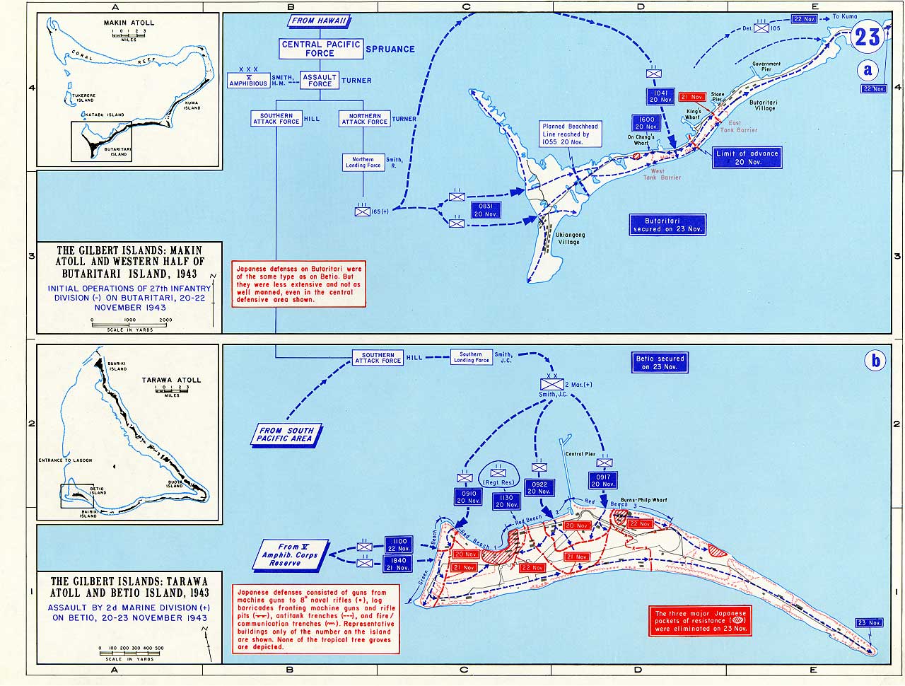
By late 1943 American naval construction, air training, and amphibious planning had progressed enough to permit a systematic advance through Micronesia. The opening move came in the Gilbert Islands. The capture of Tarawa and Makin in November 1943 demonstrated both the increasing reach of Allied power and the formidable cost of attacking fortified atolls. Tarawa in particular showed that future operations would require more careful hydrographic intelligence, longer preparatory bombardment, and refined amphibious doctrine. The Central Pacific campaign thus ended not with final decision, but with the United States fully committed to the long drive westward.
Courtesy of the U.S. Military Academy, The West Point Atlas for The Second World War: Asia and the Pacific
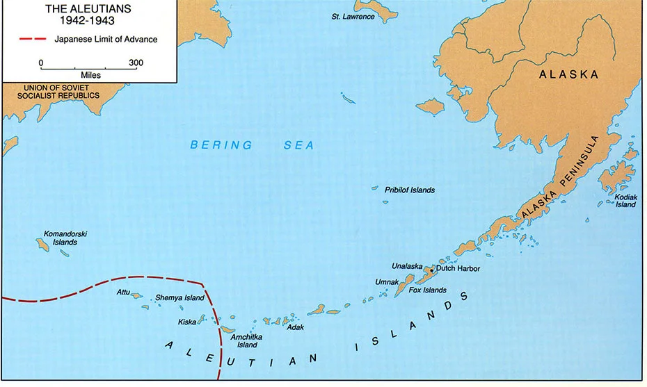
The Aleutian campaign began when Japanese forces struck Dutch Harbor and occupied Attu and Kiska in June 1942 as part of the wider operation associated with Midway. Although the islands held limited direct strategic value, their occupation represented the only enemy seizure of American territory during the war. The political effect was considerable, and the United States committed air, naval, and ground forces to eject the garrisons despite the campaign’s peripheral location.
Combat in the Aleutians was shaped as much by weather and geography as by enemy action. The Eleventh Air Force operated in conditions of fog, violent wind, cold, and chronic overcast that made navigation and bombing hazardous. On Attu, American troops of the 7th Infantry Division landed in May 1943 and found themselves fighting through bog, snow, ridges, and ravines against a determined Japanese defense. The campaign culminated in the final Japanese banzai attack on 29 May. Although Attu was secured, the battle imposed heavy losses and demonstrated how difficult operations in the North Pacific could become even against a relatively small enemy force.
The recapture of Kiska in August 1943 ended more abruptly. A large Allied landing force found that the Japanese had already evacuated the island under cover of fog. Even so, the campaign remained costly in accident and confusion. The Aleutian operations secured the northern Pacific flank, removed a political embarrassment, and provided hard lessons in joint warfare under extreme climatic conditions. Though overshadowed by the greater campaigns farther south, the Aleutians reminded Allied commanders that geography and weather could become combatants in their own right.
Courtesy of the U.S. Military Academy, The West Point Atlas for The Second World War: Asia and the Pacific
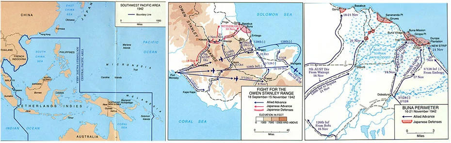
The Papua campaign marked the first major Allied ground counteroffensive in the Southwest Pacific. After Japan’s advances through Southeast Asia and the Netherlands East Indies, Port Moresby became the key to Australia’s northern approaches. Japanese forces moved overland from the north coast of New Guinea across the Owen Stanley Mountains by way of the Kokoda Trail, while Allied commanders struggled to hold the line with understrength and exhausted Australian units.
The fighting along the Kokoda Trail was among the harshest of the war. Steep mountain tracks, jungle, rain, disease, and severe supply problems defined the campaign. Australian troops fought a prolonged delaying action before gradually recovering the initiative. Meanwhile, American forces entered the battle in growing numbers. The U.S. 32nd Infantry Division, committed with little jungle training, moved into one of the most difficult combat environments any American division would face in the war. By late 1942 Australian and American troops converged on the Japanese beachheads at Buna, Gona, and Sanananda.
The struggle against those positions became a brutal battle of attrition. Japanese bunkers, tropical disease, inadequate transport, and poor tactical visibility slowed every advance. Buna fell early in January 1943, and organized resistance in the beachhead area ended later that month. The campaign secured Port Moresby and removed the immediate danger to Australia. It also established the operational pattern that would dominate later fighting in New Guinea: short-range battles in appalling terrain, where disease and exhaustion often claimed more men than direct enemy fire.
Courtesy of the U.S. Military Academy, The West Point Atlas for The Second World War: Asia and the Pacific
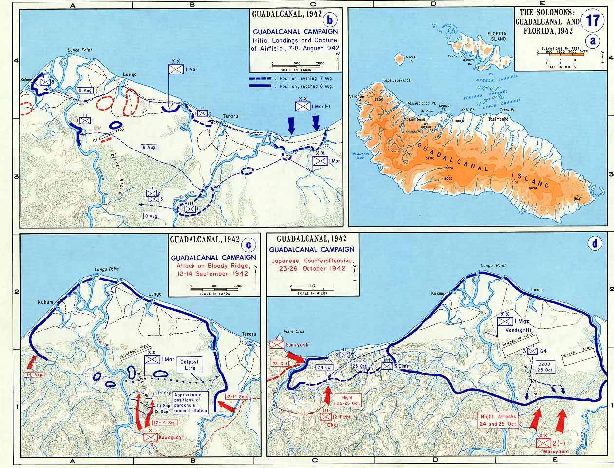
Guadalcanal was the first major Allied offensive of the Pacific war and the campaign in which Japan lost the strategic initiative. On 7 August 1942, the 1st Marine Division landed on Guadalcanal and nearby islands, seizing an unfinished airfield that soon became Henderson Field. The battle that followed centered on control of that airfield and the sea lanes around the Solomon Islands.
The campaign was fought simultaneously on land, at sea, and in the air. Japanese efforts to retake Henderson Field produced repeated infantry assaults and major naval battles, including Savo Island, Cape Esperance, and the Naval Battle of Guadalcanal. On land, Marines and later Army units repelled determined attacks against the American perimeter and gradually pushed westward. The arrival of the Americal Division and the 25th Infantry Division strengthened the Allied position and gave the campaign growing Army weight in its later phases.
By early 1943 Japanese leaders concluded that Guadalcanal could not be retaken at acceptable cost. They evacuated surviving troops in February, ending a campaign that had consumed ships, aircraft, and highly trained personnel at a rate Japan could not sustain. Guadalcanal secured the sea approaches to Australia and New Zealand and demonstrated that Allied forces could defeat the Japanese in sustained offensive operations. It was not the end of the Pacific war’s uncertainty, but it marked the point at which the long Allied advance began.
Courtesy of the U.S. Military Academy, The West Point Atlas for The Second World War: Asia and the Pacific
 6th Infantry Division
 11th Airborne Division
 24th Infantry Division
 31st Infantry Division
 32nd Infantry Division
 33rd Infantry Division
 37th Infantry Division
 41st Infantry Division
 43rd Infantry Division
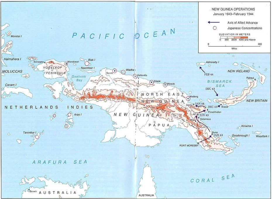
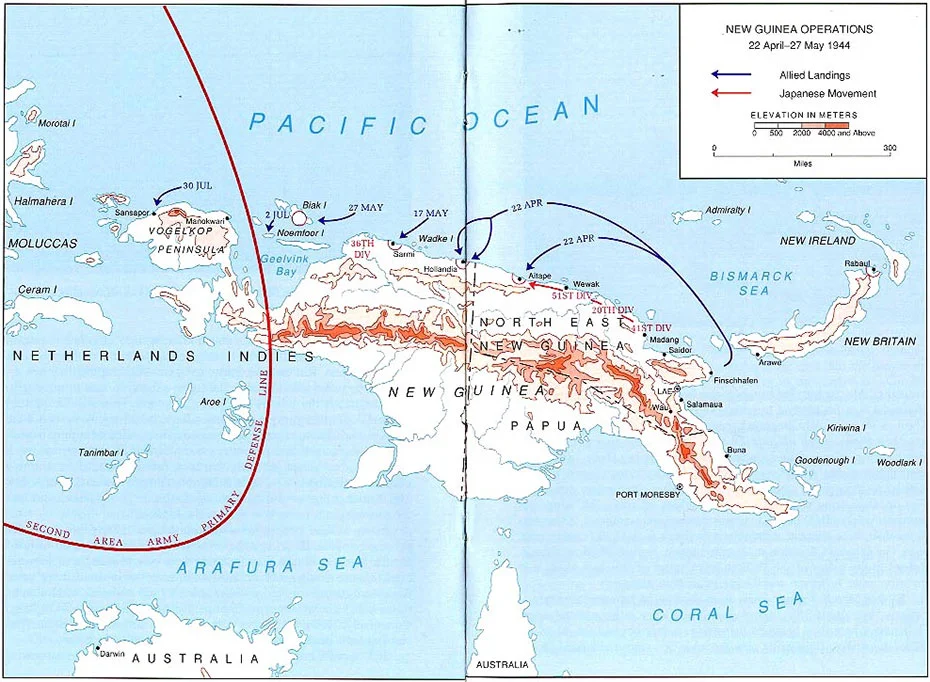
The New Guinea campaign became one of the longest and most exhausting operations of the Pacific war. Under General Douglas MacArthur’s Southwest Pacific Area command, Allied forces advanced westward along New Guinea’s northern coast through jungle, swamp, mountain barriers, and some of the harshest climates encountered by American troops in World War II. Disease remained a constant and often more dangerous enemy than Japanese fire.
The campaign’s rhythm was established in 1943. Air power under General George C. Kenney played a decisive role, especially in the Battle of the Bismarck Sea, which destroyed an important Japanese reinforcement convoy and helped force the enemy onto the defensive. The later operations against Salamaua, Lae, and Nadzab combined Australian ground action with American airborne and amphibious mobility. MacArthur then increasingly adopted a leapfrogging method, bypassing major Japanese concentrations and isolating them rather than reducing every position frontally.
This pattern continued in 1944 at Hollandia, Aitape, Biak, Noemfoor, Sansapor, and related operations. The campaign steadily expanded Allied air and naval reach while leaving large Japanese forces stranded far behind the front. By the end of 1944, New Guinea had become the logistical and operational springboard for the return to the Philippines. The campaign’s importance lay not in one decisive battle, but in a cumulative process of attrition, bypass, and relentless advance that broke Japan’s ability to hold the Southwest Pacific.
Courtesy of the U.S. Military Academy, The West Point Atlas for The Second World War: Asia and the Pacific
Courtesy of the U.S. Military Academy, The West Point Atlas for The Second World War: Asia and the Pacific
 Americal Division
 25th Infantry Division37th Infantry Division43rd Infantry Division
 93rd Infantry Division
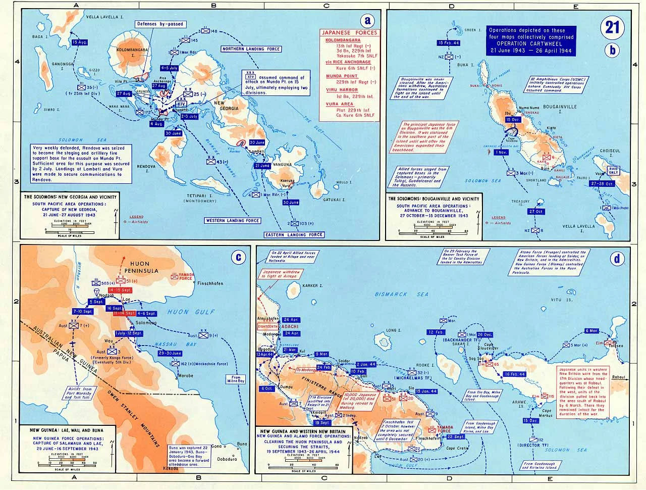
The Northern Solomons campaign formed the eastern arm of Operation CARTWHEEL, the Allied effort to isolate Rabaul without storming it directly. Admiral William F. Halsey’s South Pacific forces advanced northwest up the Solomon chain while MacArthur’s forces pushed along New Guinea. The campaign required close cooperation among Army, Navy, Marine, and Allied formations over a vast maritime battlespace.
The struggle for New Georgia in 1943 showed how difficult even secondary objectives could become in the Solomons. Dense jungle, poor trails, and well-concealed defenses turned the advance on Munda into a costly and exhausting operation. The 43rd Infantry Division bore much of the burden, and the campaign underscored how rapidly combat fatigue and disease could reduce effectiveness in tropical conditions. Yet once Munda fell, Allied commanders increasingly bypassed strongpoints rather than attacking them directly, isolating Kolombangara and moving instead to Vella Lavella.
The final major stage came at Bougainville, where Allied forces established a perimeter at Empress Augusta Bay and built airfields from which they could neutralize Rabaul. Army formations, particularly the 37th Infantry Division, later played a major role there alongside Marine units. By late 1944 Rabaul had been rendered strategically useless without the need for a direct assault. The Northern Solomons campaign therefore stands as a clear example of the Allied preference for encirclement and neutralization over costly frontal attack.
Courtesy of the U.S. Military Academy, The West Point Atlas for The Second World War: Asia and the Pacific
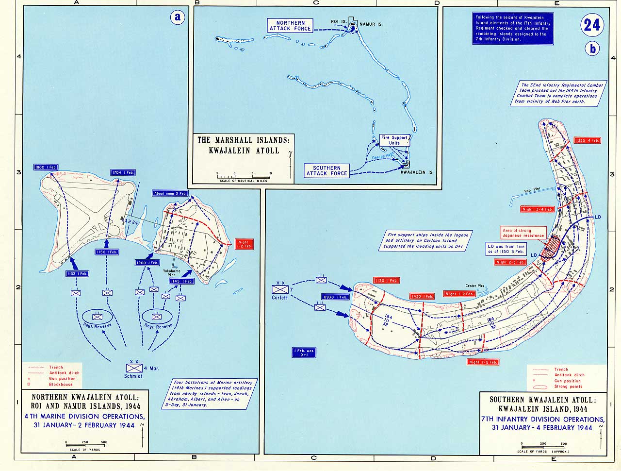
The Eastern Mandates campaign carried the Central Pacific advance into the Marshall Islands and decisively breached Japan’s outer perimeter. Admiral Nimitz opened the campaign with Operation FLINTLOCK at the end of January 1944, striking Kwajalein Atoll with Army and Marine forces in a carefully prepared amphibious assault. Lessons learned from Tarawa were directly applied in the form of heavier bombardment, better intelligence, and improved landing coordination.
Kwajalein and Roi-Namur fell quickly by Pacific standards, demonstrating that the Allies were mastering the technical problem of atoll assault. Success there allowed an accelerated move against Eniwetok in February. That operation, executed by Marine and Army forces, also ended in rapid success. At the same time, carrier raids against Truk helped neutralize what had once been one of Japan’s principal forward naval bases in the Carolines.
The campaign’s importance lay in both its operational results and its demonstration of increasing American tempo. The Marshalls gave the United States advanced bases from which to project air and naval power toward the Marianas and the Philippines. Just as importantly, they proved that the American Pacific advance could proceed faster than many planners had first imagined. The Eastern Mandates campaign marked the point at which Japanese outer defenses began to collapse in quick succession.
Courtesy of the U.S. Military Academy, The West Point Atlas for The Second World War: Asia and the Pacific
The Bismarck Archipelago campaign was MacArthur’s principal effort to isolate Rabaul from the west while Halsey closed in from the Solomons. Rather than attack the massive Japanese bastion directly, Allied commanders chose to seize the surrounding positions that would sever its sea and air connections. The result was one of the clearest demonstrations of the bypass strategy in the Pacific.
The campaign opened with the landings at Arawe and Cape Gloucester on New Britain in December 1943. These operations secured the western approaches to the Vitiaz and Dampier Straits and provided airfields and anchorages useful for subsequent advances. The most consequential operation, however, came in the Admiralty Islands in early 1944. What MacArthur initially described as a reconnaissance in force at Los Negros developed into a larger battle in which the 1st Cavalry Division secured Manus and nearby islands after determined fighting.
Once the Admiralties were in Allied hands, Rabaul was effectively isolated. Its large garrison remained in place but could no longer influence the broader course of the war. The campaign confirmed the strategic value of selective amphibious operations aimed at neutralizing major enemy concentrations without the need to destroy them in direct assault. It also provided bases that directly supported the return to the Philippines later in 1944.
 1st Cavalry Division
 27th Infantry Division31st Infantry Division
 77th Infantry Division
 81st Infantry Division
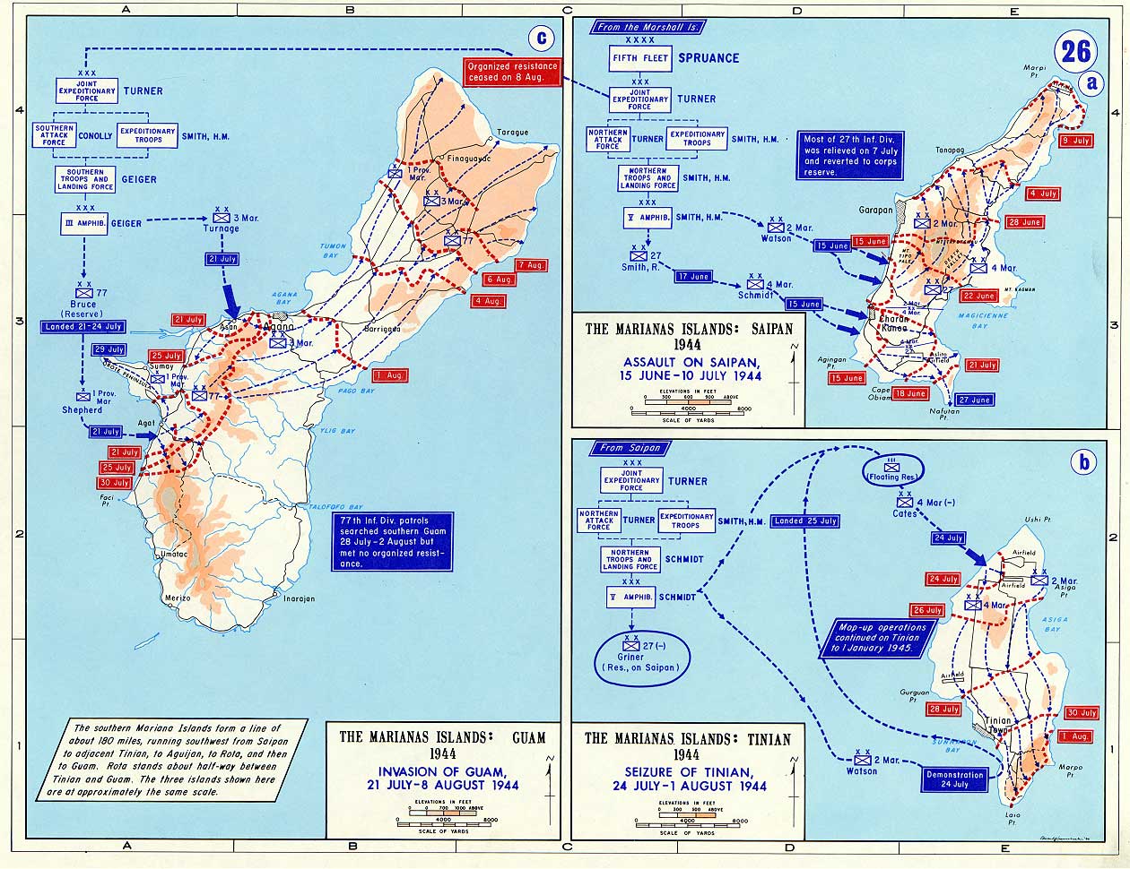
The Western Pacific campaign carried Allied operations through the Marianas, Palau Islands, and related objectives that brought American power within effective range of Japan itself. The central battle of the campaign was the conquest of the Marianas. Saipan fell after hard fighting in June and July 1944, while Tinian and Guam followed soon afterward. The capture of these islands gave the United States bases from which B-29 bombers could strike the Japanese home islands.
While Saipan was still in dispute, the Japanese fleet attempted to intervene. The Battle of the Philippine Sea in June 1944 destroyed much of Japan’s remaining carrier air strength and ensured that the United States would control the air over subsequent operations. The loss had strategic consequences in Tokyo as well as at sea. Later in the summer and autumn, the campaign extended to the Palaus and Morotai. Peleliu in particular proved far more costly than anticipated, while Morotai offered an advanced base of considerable value for MacArthur’s return to the Philippines.
The Western Pacific campaign therefore served two purposes. It destroyed the last effective remnant of Japanese carrier aviation and gave the Allies positions from which to strike both the Philippines and Japan itself. The campaign’s end date extends to the formal surrender in September 1945 because the western Pacific remained central to the final bombardment, naval blockade, and strategic pressure that ended the war.
Courtesy of the U.S. Military Academy, The West Point Atlas for The Second World War: Asia and the Pacific
Americal Division1st Cavalry Division 7th Infantry Division11th Airborne Division24th Infantry Division32nd Infantry Division77th Infantry Division81st Infantry Division
 96th Infantry Division
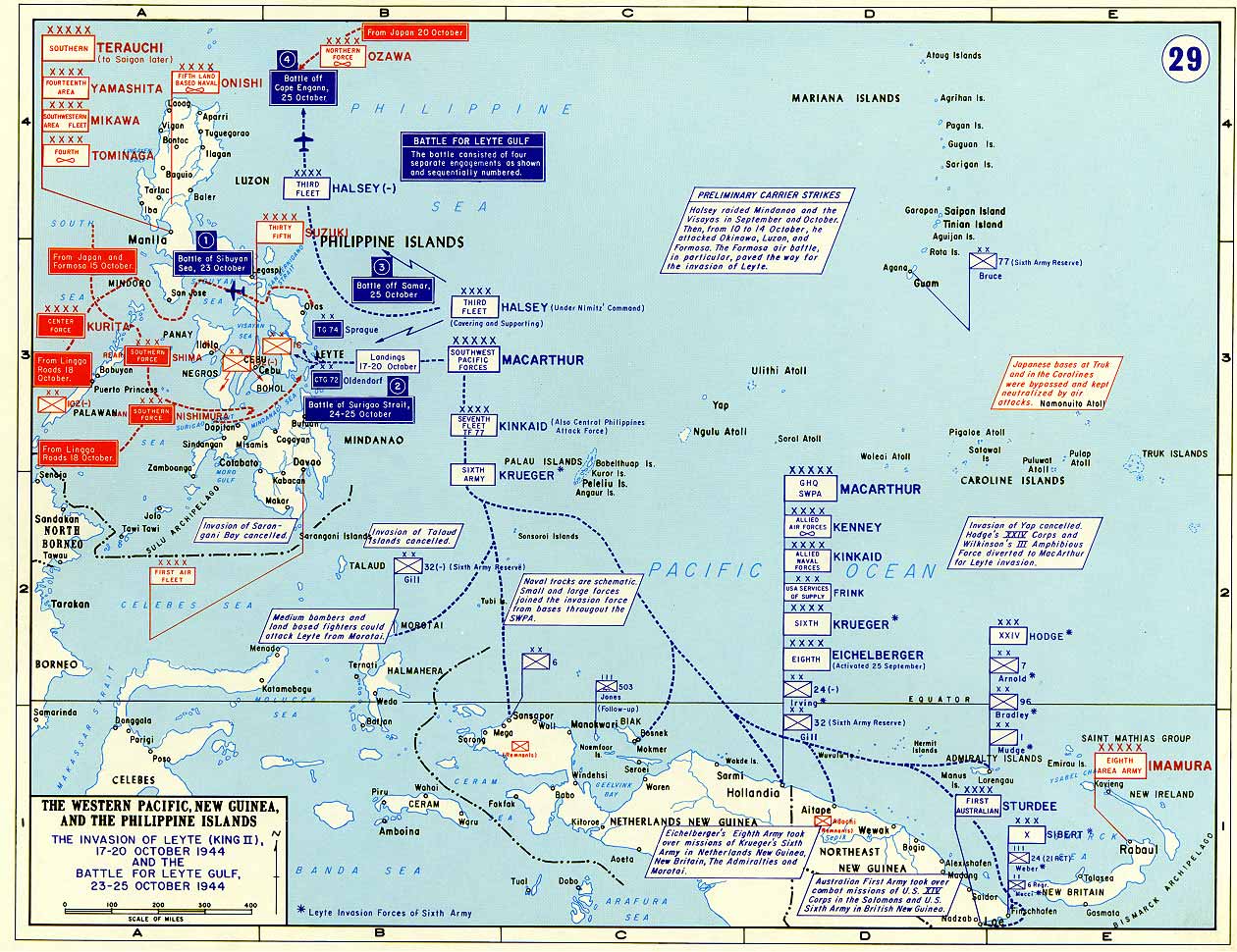
The Leyte campaign marked MacArthur’s return to the Philippines. Sixth Army under General Walter Krueger landed on Leyte on 20 October 1944 after preliminary operations had opened the way. The initial assault encountered less opposition than expected on the beaches, but the larger campaign quickly became more difficult as Japanese reinforcements entered the battle and terrain channeled operations into narrow, muddy corridors.
The naval dimension of the campaign was enormous. In the Battle of Leyte Gulf, Japan committed the bulk of its remaining major naval forces in an attempt to destroy the invasion fleet. The result was one of the largest naval battles in history and the effective destruction of Japan’s navy as an offensive instrument. At the same time, the campaign saw the organized introduction of the kamikaze as a major weapon. On land, fighting intensified around Ormoc and in the mountainous interior, and the campaign extended far beyond initial expectations.
The seizure of Leyte nevertheless achieved its main strategic purpose. It gave the Allies a major foothold in the central Philippines and set the conditions for the invasion of Luzon. The campaign also demonstrated that Japanese resistance in the Philippines would be sustained and multifaceted, combining naval counterstroke, air suicide attack, and stubborn ground defense in difficult terrain.
Courtesy of the U.S. Military Academy, The West Point Atlas for The Second World War: Asia and the Pacific
1st Cavalry Division6th Infantry Division11th Airborne Division24th Infantry Division25th Infantry Division32nd Infantry Division33rd Infantry Division37th Infantry Division 38th Infantry Division
 40th Infantry Division41st Infantry Division43rd Infantry Division
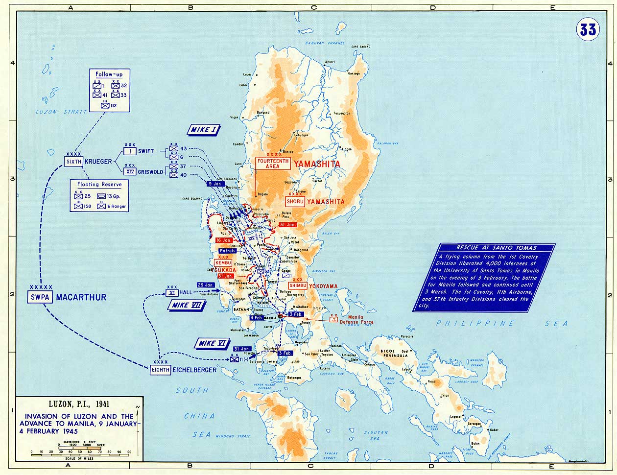
The Luzon campaign was the largest American ground operation of the Pacific war. Preliminary operations at Mindoro in December 1944 established airfields that supported the main landing at Lingayen Gulf on 9 January 1945. Krueger’s Sixth Army came ashore in overwhelming strength, but Japanese commander General Tomoyuki Yamashita declined to defend the central plain and instead dispersed his forces into mountain strongholds intended to impose a long campaign of attrition.
The fighting for Manila became the campaign’s most famous and most tragic episode. Although 1st Cavalry Division elements reached the city quickly, the battle that followed was a prolonged urban struggle in which Japanese naval troops fought with great ferocity. The liberation of the capital came at immense cost to the civilian population. At the same time, American forces fought major subsidiary actions for Clark Field, Corregidor, and the mountain defenses east and north of Manila.
Even after MacArthur declared Luzon liberated on 4 July 1945, organized Japanese resistance persisted in the highlands. The campaign’s true significance lies in its scale: it committed more American ground power than any other Pacific campaign, liberated the political and economic heart of the Philippines, and fixed large Japanese forces in positions from which they could no longer influence the outcome of the war. Luzon was both a liberation campaign and a final demonstration of the scale of U.S. land power in the Pacific.
Courtesy of the U.S. Military Academy, The West Point Atlas for The Second World War: Asia and the Pacific
Americal Division6th Infantry Division31st Infantry Division33rd Infantry Division38th Infantry Division40th Infantry Division41st Infantry DivisionThe Southern Philippines campaign was conducted by Eighth Army under Lieutenant General Robert L. Eichelberger. It consisted of a wide-ranging series of amphibious operations designed to liberate the central and southern islands of the archipelago while Japanese forces on Luzon were still being engaged. The campaign was notable for its pace, geographic breadth, and close cooperation with Filipino guerrilla forces.
Operations began on Palawan and then expanded rapidly to Zamboanga, the Visayas, and Mindanao. Local guerrilla resistance networks proved invaluable, providing intelligence, local guides, and operational support. In many cases they helped disorganize Japanese garrisons before the main assaults went in. The campaign thus combined conventional amphibious warfare with an unusually important indigenous resistance component.
Mindanao, the largest objective, required the heaviest fighting. American divisions and guerrilla forces pushed through difficult river and mountain country against a Japanese force that proved more resilient than some planners had expected. By July 1945 the campaign had effectively liberated the southern Philippines, though isolated Japanese groups remained in the interior until the general surrender. The campaign demonstrated how rapidly the United States could conduct dispersed amphibious operations once Japanese sea and air power had been broken.
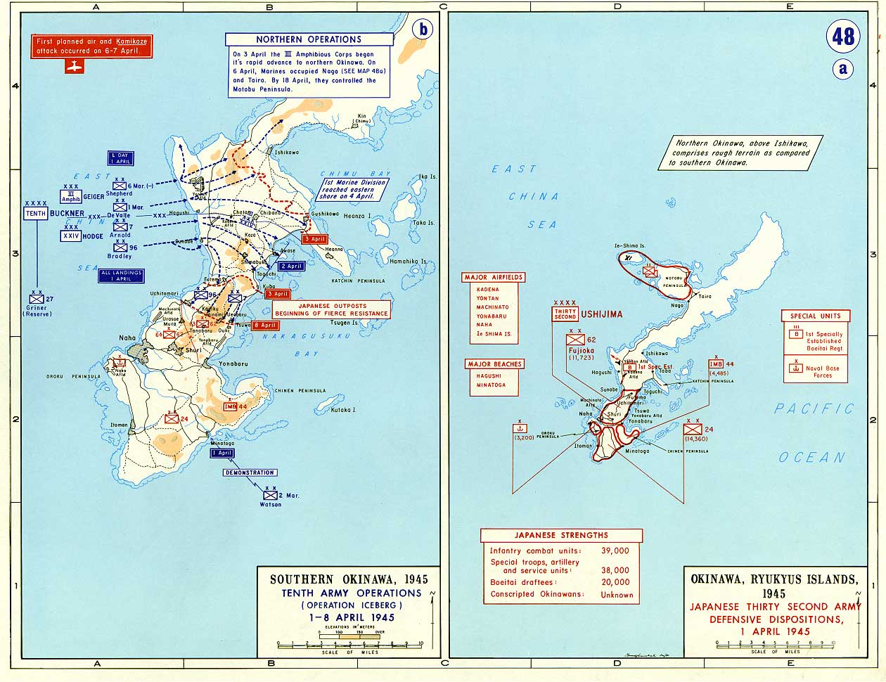
The Ryukyus campaign, centered on Okinawa, was the largest amphibious operation of the Pacific war and the final major campaign before the projected invasion of Japan. General Simon Bolivar Buckner Jr.’s Tenth Army, composed of Army and Marine corps, landed on Okinawa after preliminary seizures of the Kerama Retto islands in March 1945. The main landings on 1 April achieved surprise and rapid initial progress.
The apparent ease of the opening soon gave way to one of the fiercest campaigns of the war. Japanese commander General Mitsuru Ushijima concentrated his main strength in the fortified defenses of southern Okinawa, especially the Shuri Line. American forces were forced into a methodical and extremely costly offensive against cave systems, ridges, escarpments, and mutually supporting strongpoints. Offshore, the fleet faced the greatest sustained kamikaze campaign of the war.
By late June the main Japanese position had collapsed, and organized resistance formally ended in early July. The campaign’s cost profoundly affected Allied planning for the invasion of Japan. Okinawa revealed with brutal clarity what a home-island campaign might require in casualties, shipping losses, and time. In that sense, the Ryukyus campaign was not only the last great battle of the Pacific war, but also the operation that shaped thinking about how the war would be ended.
Courtesy of the U.S. Military Academy, The West Point Atlas for The Second World War: Asia and the Pacific