 1st Infantry Division
 2nd Armored Division
 2nd Infantry Division
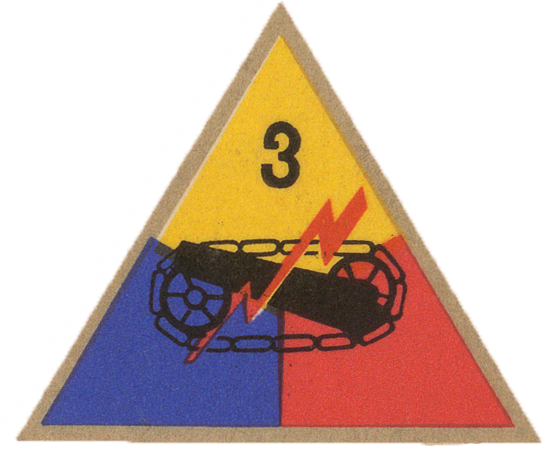 3rd Armored Division
 4th Infantry Division
 5th Armored Division
 5th Infantry Division
 8th Infantry Division
 9th Infantry Division
 28th Infantry Division
 29th Infantry Division
 30th Infantry Division
 35th Infantry Division
 79th Infantry Division
 82nd Airborne Division
 83rd Infantry Division
 90th Infantry Division
 101st Airborne Division
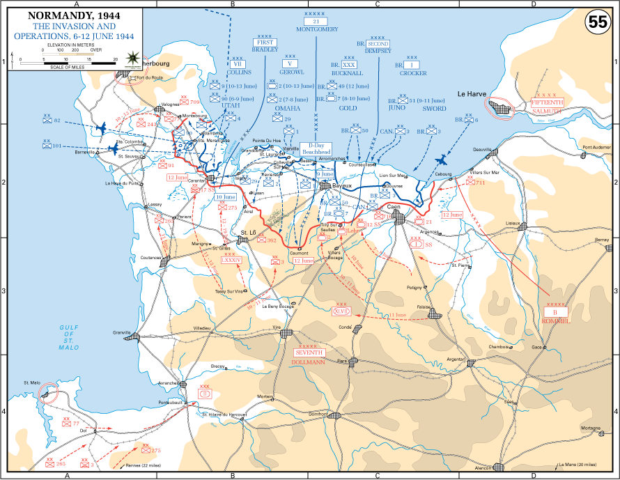
Operation OVERLORD began on 6 June 1944, when Allied forces under General Dwight D. Eisenhower landed on five beaches along the Normandy coast. General Sir Bernard Montgomery directed the initial ground campaign, with General Omar Bradley’s First U.S. Army landing at Utah and Omaha and General Sir Miles Dempsey’s British Second Army at Gold, Juno, and Sword. At Omaha Beach, strong German defenses inflicted heavy casualties on the assaulting American divisions, and the landing succeeded only after determined small-unit action and naval gunfire support opened exits from the beach. Airborne forces of the 82d and 101st Airborne Divisions secured key approaches inland and disrupted German movement.
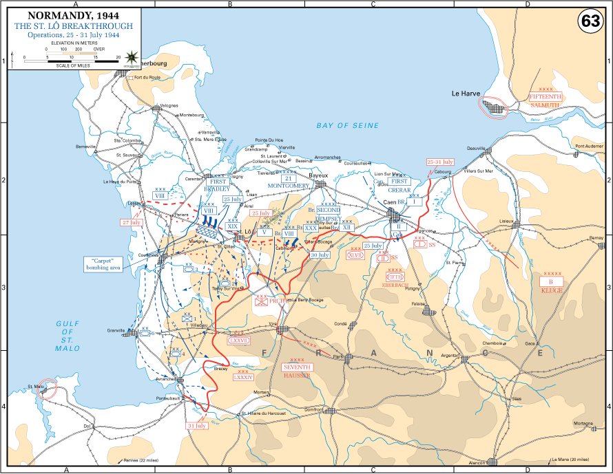
In the weeks that followed, the Allies expanded the lodgment against stubborn resistance in the bocage country. Cherbourg fell on 26 June, though its port facilities had been extensively damaged. British and Canadian forces fought prolonged battles for Caen, securing the city in July but failing to achieve a decisive breakout to the east. By late July, the front remained constrained, but German forces had been worn down in continuous fighting and were increasingly unable to replace losses. The conditions were set for the breakout from Normandy.
Courtesy of the U.S. Military Academy, The West Point Atlas for The Second World War Europe and the Mediterranean
2nd Armored Division2nd Infantry Division3rd Armored Division 4th Armored Division4th Infantry Division5th Armored Division5th Infantry Division
 6th Armored Division
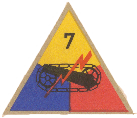 7th Armored Division8th Infantry Division9th Infantry Division
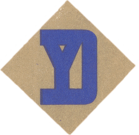 26th Infantry Division28th Infantry Division29th Infantry Division30th Infantry Division35th Infantry Division79th Infantry Division
 80th Infantry Division83rd Infantry Division90th Infantry Division
Operation COBRA opened on 25 July 1944 with a concentrated air bombardment followed by an attack by VII Corps south of Saint-Lô. Despite losses from short bombing, the assault broke through weakened German defenses. American armored forces exploited the gap, driving toward Avranches and opening the route into Brittany and the interior of France.
General George S. Patton’s Third Army became operational on 1 August and advanced rapidly in multiple directions. A German counterattack at Mortain failed to cut the American corridor, and Allied forces moved to encircle German formations in the Falaise sector. The resulting pocket inflicted severe losses, though significant numbers of German troops escaped before it was fully closed on 21 August.
Paris was liberated on 25 August, and Allied armies advanced quickly across northern France, crossing major rivers and approaching the German frontier by mid-September. The rapid pursuit strained supply lines and marked the transition from mobile operations to the more deliberate fighting that followed along the German border.
Courtesy of the U.S. Military Academy, The West Point Atlas for The Second World War Europe and the Mediterranean
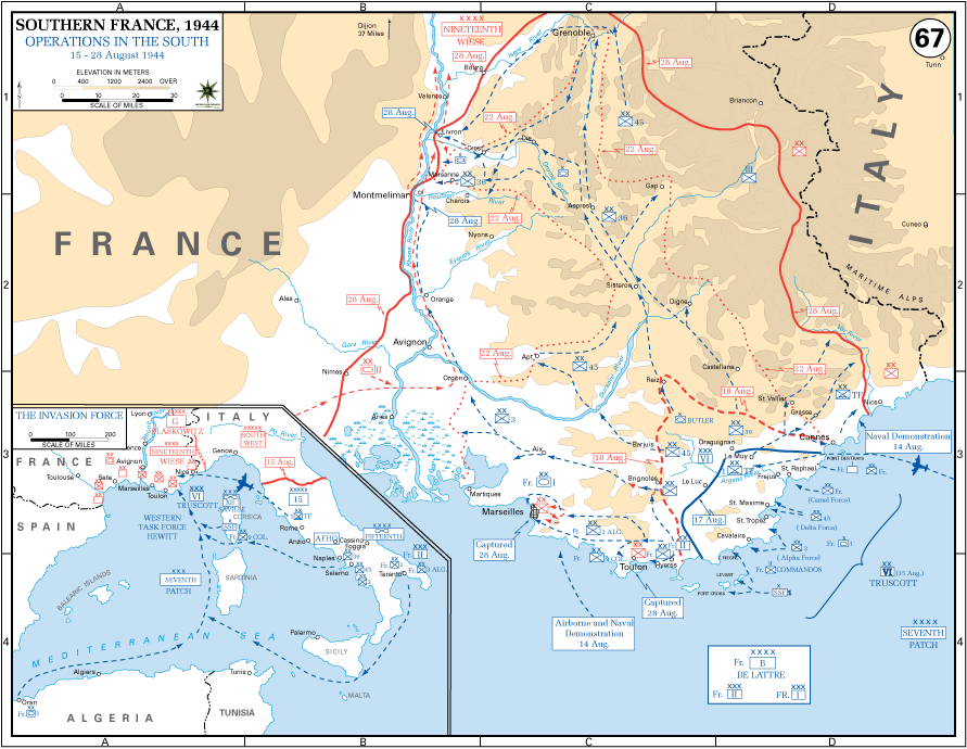
Operation DRAGOON began on 15 August 1944, when Allied forces under General Alexander Patch landed along the southern coast of France. VI Corps under Major General Lucian K. Truscott led the assault, encountering relatively light resistance. Airborne forces secured key inland routes, while French forces advanced on major ports.
Toulon and Marseille were captured by the end of August after determined fighting, providing the Allies with vital logistical bases. Meanwhile, German Nineteenth Army forces withdrew northward under pressure from Allied ground advances and resistance activity. Attempts to cut off the retreat at Montélimar achieved only partial success.
On 11 September, forces advancing from southern France linked with elements of Third Army near Dijon, uniting the Allied front. The Rhône valley then became a major supply route supporting continued operations in France.
Courtesy of the U.S. Military Academy, The West Point Atlas for The Second World War Europe and the Mediterranean
1st Infantry Division2nd Armored Division2nd Infantry Division3rd Armored Division 3rd Infantry Division4th Armored Division4th Infantry Division5th Armored Division5th Infantry Division6th Armored Division7th Armored Division
 8th Armored Division8th Infantry Division
 9th Armored Division9th Infantry Division
 10th Armored Division
 11th Armored Division
 12th Armored Division
 14th Armored Division
 17th Airborne Division26th Infantry Division28th Infantry Division29th Infantry Division30th Infantry Division35th Infantry Division
 36th Infantry Division
 42nd Infantry Division
 44th Infantry Division
 45th Infantry Division
 63rd Infantry Division
 65th Infantry Division
 66th Infantry Division
 69th Infantry Division
 70th Infantry Division
 71st Infantry Division
 75th Infantry Division
 76th Infantry Division
 78th Infantry Division79th Infantry Division80th Infantry Division82nd Airborne Division83rd Infantry Division
 84th Infantry Division
 87th Infantry Division
 89th Infantry Division90th Infantry Division
 94th Infantry Division
 95th Infantry Division
 97th Infantry Division
 99th Infantry Division
 100th Infantry Division101st Airborne Division
 102nd Infantry Division
 103rd Infantry Division
 104th Infantry Division
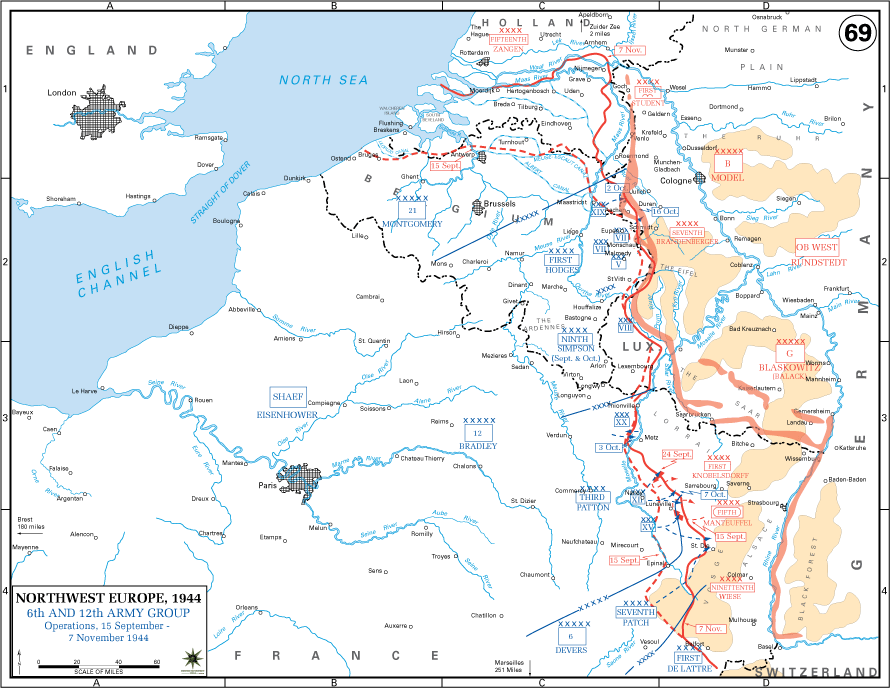
By September 1944 the Allied advance had reached the German frontier and encountered the fortified defenses of the West Wall. Efforts to outflank these positions, including Operation MARKET GARDEN, failed to secure a decisive crossing of the Rhine. At the same time, supply difficulties and strengthening German resistance slowed the Allied advance.
American forces fought a series of costly battles along the frontier. Aachen fell in October after heavy urban combat, becoming the first German city captured. In November, Third Army took Metz after prolonged fighting, while other formations advanced through the Hürtgen Forest and the Vosges Mountains under difficult conditions.
Operations were interrupted in December by the German Ardennes offensive. After its containment, Allied forces resumed the advance in early 1945, reaching the Rhine along a broad front. On 7 March, elements of the 9th Armored Division captured the Ludendorff Bridge at Remagen intact, securing a vital bridgehead east of the river. By late March, Allied forces were positioned for the final crossings into Germany.
Courtesy of the U.S. Military Academy, The West Point Atlas for The Second World War Europe and the Mediterranean
1st Infantry Division2nd Armored Division2nd Infantry Division3rd Armored Division3rd Infantry Division4th Armored Division4th Infantry Division5th Infantry Division6th Armored Division7th Armored Division8th Armored Division8th Infantry Division9th Armored Division9th Infantry Division10th Armored Division11th Armored Division12th Armored Division14th Armored Division17th Airborne Division26th Infantry Division28th Infantry Division30th Infantry Division35th Infantry Division44th Infantry Division45th Infantry Division75th Infantry Division78th Infantry Division79th Infantry Division80th Infantry Division82nd Airborne Division84th Infantry Division87th Infantry Division90th Infantry Division94th Infantry Division95th Infantry Division99th Infantry Division100th Infantry Division101st Airborne Division102nd Infantry Division103rd Infantry Division104th Infantry Division 106th Infantry Division
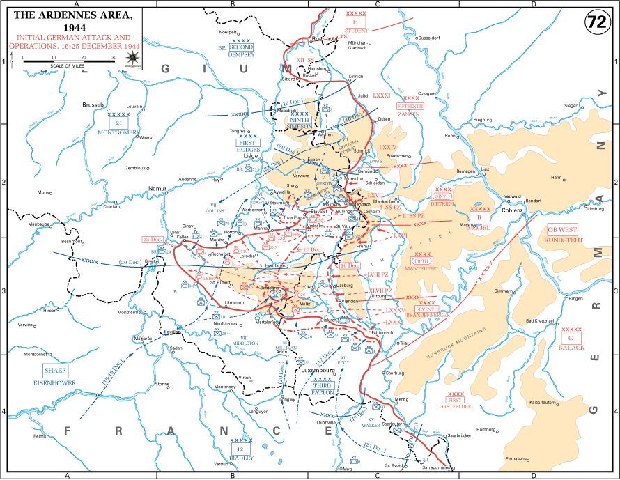
On 16 December 1944, German forces launched a major offensive through the Ardennes, achieving surprise against thinly held American positions. The attack created a deep salient in the Allied line and threatened key logistical centers.
American units conducted determined delaying actions at critical points such as St. Vith and Bastogne. The 101st Airborne Division held Bastogne under encirclement until relieved by elements of Third Army on 26 December. Allied command adjustments and coordinated counterattacks gradually reduced the German penetration.
Simultaneously, German forces launched Operation NORDWIND in Alsace, placing additional pressure on Allied lines. By late January 1945, both offensives had failed, and the front was restored. German losses in men and equipment were severe and could not be replaced, weakening their ability to resist subsequent Allied offensives.
Courtesy of the U.S. Military Academy, The West Point Atlas for The Second World War Europe and the Mediterranean
1st Infantry Division2nd Infantry Division3rd Armored Division4th Armored Division4th Infantry Division5th Armored Division6th Armored Division7th Armored Division8th Armored Division9th Armored Division10th Armored Division11th Armored Division12th Armored Division 13th Armored Division14th Armored Division
 16th Armored Division17th Airborne Division
 20th Armored Division26th Infantry Division28th Infantry Division29th Infantry Division42nd Infantry Division44th Infantry Division63rd Infantry Division65th Infantry Division69th Infantry Division70th Infantry Division71st Infantry Division76th Infantry Division80th Infantry Division82nd Airborne Division83rd Infantry Division84th Infantry Division
 86th Infantry Division87th Infantry Division89th Infantry Division94th Infantry Division95th Infantry Division97th Infantry Division99th Infantry Division100th Infantry Division101st Airborne Division102nd Infantry Division103rd Infantry Division104th Infantry Division
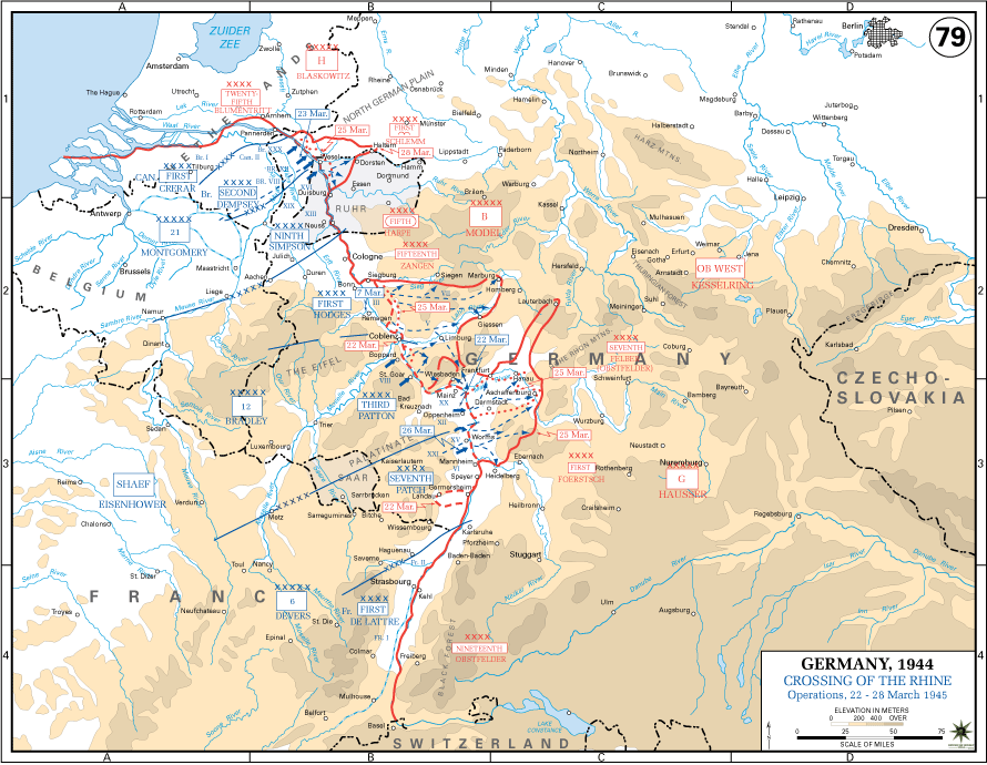
The final Allied offensive began in March 1945 with multiple crossings of the Rhine. Third Army crossed at Oppenheim on 22 March, while large-scale operations elsewhere secured additional bridgeheads. Allied forces advanced rapidly into the interior of Germany.
In early April, American forces completed the encirclement of the Ruhr, trapping a large German force that surrendered in one of the largest capitulations of the war. Allied armies then drove east and southeast, encountering increasingly disorganized resistance.
On 25 April, American and Soviet forces met at Torgau on the Elbe River, effectively dividing Germany. Allied forces continued advancing into Bavaria and Austria while occupying major cities. Germany’s unconditional surrender took effect in early May 1945, ending organized resistance in the European theater. The campaign concluded with Allied armies occupying central Europe and the collapse of the Nazi state.
Courtesy of the U.S. Military Academy, The West Point Atlas for The Second World War Europe and the Mediterranean